

SERVICES |
Engineering Surveying
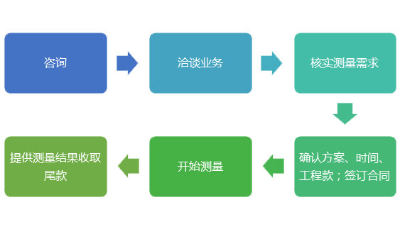
Scope of business: Provide UAV aerial survey, technical survey and remote sensing, engineering survey, topographic and cadastral survey, real estate survey, settlement and deformation monitoring survey, cadastral survey, survey boundary, square measurement calculation, GIS data processing and database building, geological hazard assessment, mineral overburden, urban planning, land planning, land consolidation and other projects technical services and project technology contracting; Rotor unmanned low-altitude photogrammetry platform, tilt measurement, low-altitude photogrammetry software, multi-dimensional data display and application platform software, three-dimensional modeling, low-altitude aerial photography engineering, tilt camera measurement engineering, conventional mapping and so on. Geographic Information System; Geographic Information Data Collection; Engineering Survey, Planning Survey, Construction Survey, Municipal Engineering Survey, Water Conservancy Engineering Survey, Line and Bridge Survey, Real Estate Survey, Completion Survey, Boundary Survey, Control Survey, Topographic Survey, Deformation (Settlement) Survey, Deformation Survey, Line Engineering Survey, Highway, Railway Survey, Level Point Addition Close repetition survey, construction lofting and laying-out, etc. Specific surveying projects can be directly consulted by telephone! |


Quality guarantee
Rapid logistics
Worry free
Service
Help Center
Quality guarantee
and invoice
Delivery as agreed,
fast delivery
7 days no reason
to return
To present a different
service for you
Your Shopping
Guide

CONTACT US

Landline:028-83232858
TEL:18980935968
Q Q:1761512639
E-mail:1761512639@qq.com
ADD:No. 25 Renmin North Road Section, Jinniu District, Chengdu, 1-4
LINKS
FOLLOW US


WeChat qr code
htc